Saturday, February 28, 2009

Google Map of All Scottish Roadworks

Scottish Road Works Online

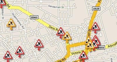
This Google Maps mashup from the Scottish Road Works Commissioner has been designed to allow the public easy access to real time information about ongoing road works anywhere in Scotland. Users are able to find out how long the works are expected to last, which organisation is carrying out the works and contact details for that organisation.

Road works are shown on the map by coloured markers to indicate the degree of impact the road works are expected to have on traffic. It is possible to search the map by area and date. Which means users are able to check planned roadworks for future journeys.

This is a great example of how governments can share public data in an informative and useful way. More please!

________________

Friday, February 27, 2009

Google Maps Friday Fun

Place de Phallus
Have a look at the two satellite images below of the Place de Terreaux in Lyon, France. The bottom one has the 'show labels' option turned on. The French sure do have imaginatively shaped roads.


Thanks to Emmanuel & Antoine for submitting this!

Dodgy Places to Eat

I'm not buying any sandwiches here.

Apparently this word has different meanings in different countries. I'm still not buying any sandwiches from here,

Via: Google Sightseeing

GeoHashing?

Geohashing is a method for finding a random location nearby and visiting it.

Via (very indirecty and not really): Yahoo Geo Technologies Blog

Thursday, February 26, 2009

Local Problems Fixed Via Google Maps

SeeClickFix

SeeClickFix is a website that allows anyone to report a local problem. For example Boston.com recently embedded a SeeClickFix map on its website to allow its readers to report potholes in the Boston area.

However, SeeClickFix is not restricted to problems with roads and users can use the map to report any kind of non-emergency issue in their neighborhood. Clicking on the map opens a ticket where the issue can be described. The idea being to publicly report an issue so the resolution can be crowdsourced.

The site resembles FixMyStreet.com, which operates a similar service in the UK. However whereas FixMyStreet reports all problems to the relevant local authority SeeClickFix doesn't restrict the fixing to local government. Anyone or any organisation can draw a watch area via a Google Map and then get alerted when something is reported in the area.

________________

Google Maps Thailand

Google Maps has launched a Thai language version of Google Maps:


Non-Thai speaking users can still view the map of Thailand in English at http://maps.google.com/. However, the Thai language version of Google Maps means that Thai speakers now have access to all the Google Maps goodies in Thai. This includes Thai My Maps and Mapplets.

So, especially for our Thai speaking readers here is a video introducing your own version of Google Maps


If you missed the Google Maps Thailand Opening Event you can check out Macroart's photographs of the event on Flickr.

To view all the Thailand maps mashups we have featured on Google Maps Mania check out:

http://googlemapsmania.blogspot.com/search/label/Thailand

________________

User Photos in Street View

Google have today added an exciting new feature to Google Maps that lets users explore popular user-contributed photos from Panoramio at major landmarks around the world.

The video below explains this new Google Maps feature:


To explore this new feture in Street View try out these famous tourist locations around the world:

Eiffel Tower, Notre Dame Cathedral, Times Square, Sydney Harbour Bridge, the Golden Gate Bridge and the Colosseum, Rome.

Via: Google LatLong: Explore more with User Photos in Street View

________________

Using Google Earth to Sell Houses

Foxtons

Most online real estate companies now use some kind of digital mapping to show the location of properties. Many companies now even use Google Maps Street View, where available, to give another perspective on homes for sale. I think however that UK real estate company Foxtons are the first to use the Google Earth browser plug-in to try and sell houses. And it works very well.

Using the Google Earth browser plug-in means that the company's customers are able to view potential properties against a backdrop of Google Earth's 3D buildings. What would be really cool is if Foxtons went a little further and actually produced 3D models of the properties for sale. That might seem a little time consuming (and expensive) but some of the properties here are over a £1 million so the commission generated could well be worth the effort.

________________

Mmm.. Pizza on a Google Map

Pizzashare

TechCrunch are (tongue-in-cheek) calling this site 'the future of mashups', which should ensure that the site is inundated with visitors. The site is a Google Maps mashup of pizza restaurants that uses crowdsourcing to locate the best pizzas. The most important thing for a site that wants to crowdsource reviews is - a crowd. The TechCrunch coverage should help get that started.

Searching for restaurants on the map is very easy. Just type in a location or zip code and press enter. Pizza restaurants are then shown on the map. The bigger the map marker the more recommendations the pizzas have had.

Using the marker size to represent popularity is a very cool feature and works very well. apparently some other cool features are in also in the pipeline, like tagging and microblogs for each pizzeria.

Via: TechCrunch

Wednesday, February 25, 2009

My Map of Amsterdam Plane Crash

Fairly soon after the crash of the Turkish Airlines Flight on landing at Amsterdam's Schiphol international airport this My Map of the crash was one of the biggest retweets on Twitter.


View Larger Map

I wasn't going to link to the map because I didn't think it added much to the news of the crash. However the map has now been picked up by a number of websites.

If you are interested at looking at the statistics about a My Map just click on the comments link on the main Google Maps page (enlarged map). The statistics about the Schiphol map are available here.

________________

Ideas for Outdoor Google Maps Mashups

Libraries & Services for Outdoor Pursuits Mashups


Bill Chadwick, of Where is the Path? fame, has produced an excellent website of libraries and services for those who are keen on creating outdoor pursuits mashups. The site includes a number of working examples of the libraries and services mashed-up with Google Maps.

One example is a Google Map mashed up with a Javascript Sunrise and Sunset calculator. As you might guess the map can show you what time the sun will rise and set anywhere in the world.

Another great example on Bill's site is a Google Map mashed-up with a Java Script Douglas-Peuker algorithm. The algorithm reduces the points in a GPX trail so that the mapped polylines load much more quickly. Anyone who wants to create a map mashup that plots GPX trails should definitely check this out.

Other examples on Bill's site include a GPX to GeoJson converter, a UK Gradient Server, a Javascript implementation of the World Magnetic Model and a UKOS Grid for Google Maps.

Via: Mapperz

________________

New Look for Google Maps API

The new design of map controls that was introduced in Google Maps last month is now available to map developers.


To add the new design to a map, developers just need to add one line of code:

// Create a map.
var map = new GMap2(myMapDiv);
// Give it the maps.google.com experience.
map.setUIToDefault();


Maps that contain this line of code will also be automatically updated if the UI of Google Maps is updated.

Here is an example of a map built using the Google Maps API with the new design of map controls - The Knossos Palace

A full reference of the functions, the GMapUIOptions class and all the defaults are available on the Google Maps API Reference.

Via: Google Geo Developers Blog: Monkey see, monkey do

________________

Harvard Map of Africa

AfricaMap

This Google Map mashup contains an amazing amount of data about the African continent. AfricaMap has been developed by the Center for Geographic Analysis at Harvard University to make spatial data on Africa easier for researchers to discover and explore.

The incredible amount of data on this map is organised into three main categories: View, Map Layers and Places. The three categories can be accessed via tabs at the top of the map.

The View tab is the one to select to view the map and to select from the different map types. The Map Layers tab is the main tab for selecting what data you wish to see presented on the map. The data is then sub-categorised into Base Mapping, Economic, Environmental, Ethno Linguistic, Ethno Classification, Harvard Collections, Historic Maps 1800 to 1950, Historic Maps 1800 to 1950, Local Projects, Period Maps, Place Names & Political and Population.

The Places tab allows users to access Place Name information across the continent by category. The database contains hundreds of Place Types for Africa (i.e. administrative divisions, populated places, farms, streams, etc.).

________________

Tuesday, February 24, 2009

Graduation Day for Map Maker

Google have today announced that 16 countries have received map updates care of Google Map Maker.


The 16 countries are:

Bhutan, Bolivia, Cambodia, Dominica, Dominican Republic, Guam, Iceland, Mauritius, Paraguay, Philippines, Senegal, Seychelles, Sri Lanka, Tajikistan, Vietnam, Zimbabwe.

Google have also put together a gallery highlighting some of the wonderful cartography completed by users of Google Map Maker.

Via: Google LatLong: Graduation day for Map Maker

________________

Street Art, QR Codes and Google Maps

The Voice of the Street

The Voice of the Street have produced this cutting edge website that allows street artists to receive feedback from members of the public.

Artists leave a QR code on their work, members of the public then take a picture of the QR code with their mobile phone and leave a voice message for the artist. I think there could be a huge call for this. I mean who hasn't seen some graffiti and wanted to leave a message for the 'artist'? I just wonder whether most of the comments are going to be what the artists want to hear.

Here's a video explaining how the service works:


The Voice of the Street from Leif on Vimeo.

________________

Satellite Crash on Google Maps

When Satellites Collide

Update: I've bumped this post back to the front page because Barnabu has now also produced a Debris Map of the collision.

Barnabu is quickly becoming my favourite destination for interesting Google Earth files. Two weeks ago Barnabu created a Twitter Snow animation in the Google Earth browser now he has created an amazing animation of the crash between the Russian Cosmos 2251 and the US iridium 33.

Here's a quick screencast:


Satellite Crash from Keir Clarke on Vimeo.

For the full interactive version you have to visit - Barnabu

Update

Barnabu has now also created a Google Earth Browser map of the debris from the crash. The Debris Map is if anything more amazing than the crash map. This map propogates the orbits of all 134 fragments from the two satellites smoothly in real time.

________________

Mardi Gras Parade Routes

New Orleans Parade Maps & Schedules

Carnival is the festival season that occurs before Lent, and which ends today with Mardi Gras (Fat Tuesday).

Nola.com has produced this schedule of today's parades in New Orleans:
Each of the above links takes you to details about the parade and a Google Map of the route.

Mobile, Alabama Parade Routes

WKRG News has produced a Google Map showing the routes of Mobile's Mardi Gras parades. Use the tabs at the top of the map to toggle through the four routes.

_____________

Languages in Danger Google Map

UNESCO Atlas of the World's Languages in Danger

Did you know that there are 192 endangered or dead languages in the United States? That figure includes Coushatta, which is spoken by 350 members of the Coushatta Tribe of Louisiana. It also includes Paviotso, which is spoken by 400 people in Oregon, Nevada, California and Idaho.

This UNESCO Google Map mashup highlights the endangered languages listed in the 2009 edition of UNESCO’s Atlas. It is possible to browse for the world's endangered languages on the map via a search box or by zooming into individual countries on the map.

The languages are shown on the map by coloured markers. The map markers reflect the level of danger to the language. Black markers indicate languages that are already dead, red markers those that are critically endangered etc...

Monday, February 23, 2009

IHOP Free Pancakes Map

Update: Where I'm At have produced a much better (and nicer looking) store locator for IHOP restaurants. Their map includes a search option or the option to click on a map and load the nearest restaurants. Where I'm At also have store locator maps for Apple, Best Buy and AT&T stores.

If they had just contacted me a little sooner I could have saved myself an hour's work :(

IHOP Free Pancake Store Map

Tuesday 24th February is IHOP Free Pancake Day 2009. IHOP wants to help you celebrate Pancake Tuesday, Fat Tuesday or Shrove Tuesday by giving you one free short stack (three) butterscotch pancake. In return IHOP hope its customers will consider donating to The Children's Miracle Network.

To help you find your nearest IHOP store I thought a Google Map of all the IHOP locations would be handy.

I created the map using Google Spreadsheets, Batchgeocode and Map Channels. One reason I went with Map Channels to create the map is that version 3 of Map Channels (released today) has a great marker clusterer. With over 1400 participating stores I definitely needed some kind of clusterer for this map.

It's Paczki Time
Well, there you go. I didn't know that today is also Happy Paczki Day (OK, I didn't even know what a Paczki is). Thankfully Mibazaar has created this map of Donut and Bagel restaurants.

If I lived near any of these restaurants I would definitely be heading out to try one.

_____________

Map Channels Version 3

Map Channels

No sooner had I posted about 360Cities latest update than Map Channels got in touch to say they have just released Map Channels Version 3. Map Channels is a website tool that lets you create and embed a custom map into your website or blog without the need for coding.

Version 3 of Map Channels includes these new features:
  • User-definable dictionaries to present maps in any language
  • Support for spreadsheet data in either tab-delimited format or from Google Spreadsheets
  • Support for GeoRSS feeds using the Google Feeds API
  • Marker clustering to display large numbers of markers on a map
  • Google Street View
  • Microsoft Virtual Earth
You can see the new clustering feature in operation on this See Bournemouth map.

_____________

360Cities New Google Map Interface

360Cities Map

The interactive panoramas website 360Cities has released a new Google Maps interface for interacting with the site's thousands of images.

The new interface uses clustering to reduce the time it takes for the map markers to load. At lower zoom levels numbered markers indicate how many images are available at a location. When you zoom in or click on the numbered markers the individual panorama markers are revealed.


When you click on a marker the interactive panorama replaces the map so that you are able to enjoy the panorama in all its glory. A small map is shown in the bottom left hand corner of the page. As you pan around in the panorama the map shows you the direction of your current view.

This is a a great update from 360Cities. It is now very similar to Google Street View but with much better photography.

Other Interactive Panorama Websites

Panedia
Nikon Indy 300
Singapore VR
Limoges 360
360 Toronto
Panoramic Earth
360 Panoramy
Czech Republic: Prague 360
360 Tuscany
Fotopanorama

_____________

Twitter & Google Maps

TweetMapper

TweetMapper allows anyone to create a map of their tweets. The map uses OpenStreetMap for the map tiles and the Google Maps API for geocoding (working out the map co-ordinates from place names mentioned in the tweets).

To map your tweets you just need to add the #at tag to your messages. A really cool feature of TweetMapper is that you can define locations. So, for example, you can set the location of your work place in TweetMapper and then use the tag #at work in Twitter to map your location.

Users of TweetMapper can embed their personal Twitter map in their websites or blog. TweetMapper can also give you a kml of your Tweets so you can view your messages in Google Earth as well.

Schmap GeoTweeter for iPhone

This new iPhone application from Schmap puts the 'where' into your tweets. Using the app your Twitter messages automatically include a 'schmap.me' link, showing followers your exact location with a configurable map icon. Previously saved places can also be retweeted, which could be useful for recommending favourite restaurants etc. and inviting followers to tweetups.

The link is added to the end of your message. When your followers click on the link they are taken to a webpage containing a map of your location and your message.

Previously Featured Twitter Maps

Short URL Services for Google Map Locations

Mapof.it - provides a really simple way to get a map or a route without first visiting Google Maps
Plazz.me - Enter your address into a search box and create a short url for Twitter.
UseAMap.com - Zoom to a location and choose your url
LookLeap - Add this bookmarklet to your browser. Click the bookmarklet when you want to create a small url

_____________

Saturday, February 21, 2009

Rap on a Map

RapMaps


"You are now about to witness the strength of street knowledge."
- Straight Outta Compton, NWA

Google Maps Street View allows anyone to explore any hood anywhere. Rap music seems the most geographically aware of music forms. So what better idea than to map rap songs so listeners can virtually explore the locations being rapped about on Google Maps?

Rapmaps does it exactly that. It is a mashup of Google Maps and YouTube rap videos. The videos are geo-tagged by their location. So when Kam sings Watts Riot you can now explore Watts on the map in Street View at the same time as watching the video.

Other Music Maps

________________

Friday, February 20, 2009

Google Map of CO2 emissions

USA CO2 Emissions
Simon Ilyushchenko, a Site Reliability Engineer at Google, has used his 20% time to produce this Google Earth Browser mashup of CO2 emissions in the US.

The map shows data from Project Vulcan, put together by a team of scientists at Purdue University. The data shows detailed emissions for all 50 US states in 2002. Using the map it is possible to see which US states and counties have the highest and the lowest emission rates - absolute or per capita. You can see where people burn more gasoline for driving, or where they use more fuel for heating and cooling their homes and businesses.

There is even a video fly-through of the map:


Via: Google LatLong: Mapping CO2 emissions

________________

Google (& other) Maps Friday Fun

Atlantis Found on Google Maps

British tabloid The Sun claim that Atlantis has been found on Google Maps. From the screenshot above you can see what does actually look like a city grid in the ocean off the Canary Islands. The grid was spotted by aeronautical engineer Bernie Bamford as he browsed through Google Ocean.

Stefan at Ogle Earth has kind of spoilt the fun however by explaining that it is "merely a grid of higher resolution sounding data amid a lower-resolution dataset, taken from a ship surveying the area. " Stefan says that "one phone-call to a serious marine scientist would have sufficed to pour cold water on this story. " Which is probably why the phone call was never made.

Update
Whilst Stefan's explanation may have been a little more boring than the Atlantis theory it has been confirmed. A Google spokeswoman confirmed this afternoon that the lines were the result of the sonar as boats mapped the ocean floor.

"It's true that many amazing discoveries have been made in Google Earth including a pristine forest in Mozambique that is home to previously unknown species and the remains of an Ancient Roman villa.

"In this case, however, what users are seeing is an artefact of the data collection process. Bathymetric (or sea floor terrain) data is often collected from boats using sonar to take measurements of the sea floor.

"The lines reflect the path of the boat as it gathers the data. The fact that there are blank spots between each of these lines is a sign of how little we really know about the world's oceans."

How to Make a My Map
You have to watch this video even if you have no interest in creating a My Map!


Goon City

I've always had a fondness for pixel art. Over the years there have been a number of pixel art cities on the internet that have grown as users build and add their own blocks. I think this is the first pixel art city to use Google Maps as an interface to view the art work.

Very cool!

When Google Maps Crashes

Via: Sedentario

Vidteq
Google Maps has a great option to view driving directions in Street View. Indian online mapping site Vidteq have gone one better - they provide video with their driving directions.

After you have entered your start and end destination Vidteq provides the driving directions and also provides a video of the route. As the video plays the position is continually updated on the map and in the written driving directions. On the video local points of interest are indicated as are all the side roads as they are passed.

Here is a video preview:


Vidteq from Keir Clarke on Vimeo.

Another UFO Caught by Street View

Google sightseeing has provided more visual proof of the little green men amongst us. You can see more Street View alien sightings on this UFO post.
Via: Google Sightseeing

Thursday, February 19, 2009

Re-enactment of Flight 1549

Flight 1549

This has to be one of the most amazing things I've seen on the interwebs!

Jeral Poskey has created a Google Earth tour that re-enacts Flight 1549's crash into the Hudson River. The re-enactment includes sound from eight audio tapes released by the FAA between pilots and controllers. To view the tour properly you need to have installed the latest version of Google Earth (Google Earth 5.0).

Jeral explains how he created the tour on his website da Vinci Global Services. The video of the re-enactment below was created by videoing my monitor, so is quite poor quality.


Flight 1549 Reenactment from Keir Clarke on Vimeo.

Also See

The Short Flight of 1549

________________

Map Maker Added to Google Maps API

Google have announced that the Chrome browser now supports the Google Earth Browser plug-in. Chrome users who have been dying to play with Google Earth in the browser should check out these Google Map Mania posts.


Google have also now officially announced that the tiles from Map Maker are available as new map types in both the Google Maps API (v2.146) and the Static Maps API as new map types.

Google Map Maker allows anyone to add map detail in areas of the world where Google Maps at the moment has little data. Check out the two maps of Sri Lanka below. The map on the right is from Map Maker and the map on the left is from Google Maps.


This Google page explains how you can add Map Maker tiles to your maps. Mapperz has created an example Map of Iceland. Just toggle between the two 'map' buttons to compare Iceland with Map Maker data turned on and off.

Via: Google Geo Developers Blog & Google Lat Long Blog

________________

Thailand Google Maps Round-up

Traffy

Traffy is a very good Google Map of traffic conditions in Bangkok. Roads on the map are coloured green, yellow or red depending on the current traffic conditions.

Traffy can also provide driving directions. If users define a start point and destination Traffy will provide the best current route, avoiding where possible traffic jams. Traffy also includes map markers of traffic cams. When you click on a camera map marker an image of the current road conditions is shown in the map sidebar.

EDTGuide

The EDT in EDTGuide stands for 'eat', 'drink' and 'travel' and this Google Maps mashup shows the best places to eat, drink and travel in Bangkok.

The site is a social sharing site so all the reviews of the bars, restaurants and other points of interest are provided by the site's members.


Both of these Google Maps come from the excellent Google Maps Fan in Thailand, which as well as providing reviews of Thai Google Maps mashups, includes tutorials in Thai on how to build your own Google Maps mashups.

Wednesday, February 18, 2009

UFO Spotters Google Map

Star UFO Watch

Yesterday we had a Google Map mashup trying to track the mysterious disappearing Buddhist dentists of Diamantina. Today we have a map tracking UFO's. The Shropshire Star has produced this Google Map to track sightings of UFO's in Shropshire, England.

Plotting the sightings in this way on a Google Map allows us to see that the UFO's are clearly using the mouth of the River Dee as a navigational aide in their targeting of the UK's industrial heartland in Birmingham.

Either that or these sightings are all from the same person.

Also Read
UFO's Caught by Street View - updated with a new Street View image today.

________________

Calgary & Edmonton Added to Google Transit


Yesterday Google quietly added Calgary and Edmonton, Canada and Belo Horizonte, Brazil to Google Transit.

In Calgary Google is working with Calgary Transit to provide bus and CTrain information. In Edmonton Google is working with the Edmonton Transit System to provide bus and train information. In Belo Horizonte Google is working with Empresa de Transportes e Transito de Belo Horizonte S/A.

Update
Google have now released information about this latest update.

Calgary, Hamilton, Edmonton, and York Region in Canada; East Midlands (UK); Houston (TX); and 21 agencies in the state of Virginia have all been given full schedules for Transit. China has also received a huge increase in transit data, connecting all provinces with 3100 train lines, covering about 2700 stations and all major cities (for example, try Beijing to Shanghai).

Adelaide, Atlanta, Bonn, Davis, California, Pilsen, Sacramento, Torino and Hamilton, Canada have had transit layers added.

The transit layers in Cape Town, Johannesburg and Pretoria have all also received recent updates.


Via: Mapperz & Google LatLong: Another round of updates for Google Transit

________________

Travel Videos on Google Maps

Mapyro

Mapyro is a travel video sharing site that lets you archive your vacation videos and show them on a Google Map. Using Mapyro you can upload and share videos, explore other user's videos via Google Maps, blog about your videos and show your videos to your friends and family.

You can also use Mapyro to organize your travel videos in the form of a trip and view your videos in the form of an entire ‘album’. What’s more, you can even write a ‘travelogue’ that describes your trip and videos in greater detail.

Other Video Mashups

Seero - live video tracking on a Google Map
MyTAGeo - Videos and webcams tagged on Google Maps
Virtual Tourism - my own video mapping site, showing hundreds of videos from around the world.
TURNHERE - a travel and video site
Virtual Video Map - a Google Map of videos from around the world
Venividiwiki - a travel site that includes a number of videos
YouTube Vision - YouTube Vision, shows the most recent geo-tagged videos from YouTube embedded on a Google Map.

________________

Tuesday, February 17, 2009

100's More Local Search Results

Until today local searches on Google Maps only plotted the first page of business results, now Google Maps plots hundreds more of the results as small circles. The top ten results still appear in the left-hand side panel and as markers on the map. However you can now also click on the other circles if you wish to search outside the top ten.

The screenshot below shows just a small percentage of the results of a search for 'pizza' in New York.

As you can see there are more than ten pizza results for this area. Now even though my nearest pizza restaurant isn't in the top ten results I can find it very quickly on the map.

Mmm pizza ...

Via: Google LatLong: 1000 is the new 10

Google Map of Dodgy Sydney Restaurants

Gastro
Gastro is a Google Maps mashup of the New South Wales (Australia) Food Authority's name-and-shame lists. It collates the Register of Offences and the Register of Penalty Notices and displays the location of offending restaurants on a map.

The map includes an interesting slidebar, which is used to load map markers onto the map. Using the slidebar it is possible to change the number of months of penalty offences loaded onto the map.

The video below shows the slidebar in use:


Gastro from Keir Clarke on Vimeo.
________________

Mapping the Downturn

Major World Indices


If you are interested in watching stock markets falling throughout the world then this is the map for you. This Google Maps mashup presents quotes of stock markets from all over the world. The quotes are updated every 10 minutes and the map gives a comprehensive overview of current global stock markets.

The markers on the map show the percentage rise and fall of the market for the day. Clicking on a marker opens an information window with the stock market points total, the total fall or rise and the percentage fall and rise.

Lay-off Maps

One of the direct consequences of all the minus signs on the Major World Indices map is rising job losses. Lay-off Maps is a mashup of self-reported job cuts in the US and around the world.

Selected lay-off news is mapped on this website, however, the focus is on individual lay-offs, rather than the large mass lay-off numbers reported in the news. The site also collects information on the profile of laid off employees, such as age, years worked, salary etc.

Lay-off Maps say that when a significant amount of people report job cuts they will then provide statistical analysis on the website.

Previously Featured

USAToday Foreclosures Map - The public records of foreclosures shown on Google Maps highlighting the impact the foreclosures are having on the Green Valley Ranch neighbourhood in Denver.

Layoff Tracker 2009 - Mibazaar created this Layoff Tracker to show the effect of the downturn on US jobs.

Mapified World Stock Indices - A Google Map showing world stock indices. The bar width shows the market capitalization.

________________

Who Are the Dentist Monks of Diamantina?

Dent-o-Tracker

Australian newspaper the Courier Mail has produced this dent-o-tracker Google Map to try and find the whereabouts of the four mysterious dentist Buddhist monks of Diamantina. Apparently the four Buddhist monks set up a dental practice in this far southwestern Queensland town, pulled a few teeth, and then promptly disappeared.

When the locals contacted the Queensland Health department to try and find out more about the mysterious molar mending monks the officials said they knew nothing about them. So where did these dentist monks come from and where have they gone?

If you have seen the monks you can use this Google Map to help the Courier Mail in its hunt. Just fill in a short form and your sighting will be added to the map. Unfortunately, so far, the map seems to consist only of people reporting that they haven't seen the monks.

________________

Finding Hotels on Google Maps

Cheaperthanhotels

Travel website Cheaperthanhotels have today unveiled a new Google Maps interface that allows travellers to compare hotel prices and locations at the same time. Apart from a few teething problems (some very weird things happen when you view the site in FireFox and Yosemite National Park has been mapped just off the coast of Nigeria) this is a good implementation of using Google Maps to search for hotels.

By combining their own dynamic pricing technology and the Google Maps API, Cheaperthanhotels enables travellers to search for accommodation using a variety of criteria and then display the appropriate hotels on a Google Map alongside the average prices.

Along with price and location comparison, the maps also incorporate:
  • A route planner – specify a journey between two or more points then view hotel options and prices mapped out along the route
  • Distance calculators – see how long it takes to travel – by foot or car - between a hotel and key attractions and/or other properties
  • Advanced filters – filter search results through a range of criteria (including hotel facilities) to pinpoint the most relevant properties
  • Google search – explore dining and entertainment options around each hotel using Google Search
Cheaperthanhotels also uses Google Street View, where available, so it is possible to get a view of the outside of the hotel and get an idea of the locale.

Via: infonews.co.nz

________________

Monday, February 16, 2009

Augmented Reailty Via Google Maps

ARSights
ARSights is a new tool that will allow users to visualize Google Earth 3D models using augmented reality. The site uses the Google Earth Browser plug-in to allow users to search for and download Google Earth 3D models.

Once you have downloaded a model all you need to do is run the ARSights application, set up your webcam and go. You will then be able to create awesome augmented reality videos like this: